This page provides links to documents that relate to locations and places within the County. Such information may have value in describing record locations within the County.
Ordnance Survey Map References
Follow THIS LINK for information on the map reference system used to identify locations on Ordnance Survey map sheets.
Tetrads
Tetrads are 2 km x 2 km squares nested within the Ordnance Survey grid. The system is used extensively in surveying plants and animal distributions by many wildlife organisations.
Each 10 km square of the OS grid (identified by two letters followed by two numbers, e.g. SO49, SJ61) is divided into 25 tetrads. These are labelled using the letters of the alphabet (but excluding “O”), arranged as follows.
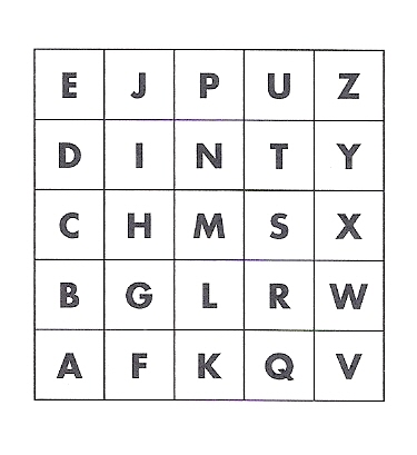
![]() This arrangement is sometimes referred to by the name “DINTY” (see the sequence of letters in the second row).
This arrangement is sometimes referred to by the name “DINTY” (see the sequence of letters in the second row).
A sampling square can then be referred to with a tetrad label such as SO49M, SJ61A etc.
The Tetrads of Shropshire
There are 870 tetrads that define SOS’s conception of Shropshire. Where a tetrad contains the County boundary, it is included if half or more of the tetrad lies within the County.
This link enables you to download a complete list of the 870 Shropshire tetrads as a MS Excel file.
This link provides a map view of County tetrads presented in the form of an MS Excel spreadsheet file.
Shropshire Tetrads and OS Maps
How is the extent of Ordnance Survey mapping cover of Shropshire related to 870 tetrads that define SOS’s Shropshire?
The following two downloads (Word Excel files) depict this for two popular scales of OS map. On a schematic outline of the County, each OS map sheet has been randomly allocated a colour and its OS map number and coverage are shown. In the top left-hand corner of each ten km square (solid lines) is the square’s number (to be preceded by SJ in the north of the county and by SO in the south). Also shown on the map are the boundaries of tetrads (dotted) with a key to the naming of tetrads in the top right. The two-character initials show the approximate positions of town-centres and of villages.
- The OS 1:50,000 scale ‘Landranger’ maps (2cm to 1km, not far off the old “one inch to the mile”). There are no overlaps in coverage in this map series. Download here.
- The OS 1:25,000 scale (4cm to 1km) ‘Explorer’ maps. There are some overlaps in coverage with this map series. The southern edge of map 216 (Welshpool) and the northern edge of map 210 (Knighton), where the two cover the same ground, is shown by crosses. Download here.
The Shropshire Gazetteer
The Shropshire Gazetteer is a 240-page listing (in pdf format) of locations within the County with associated six-figure map references. Download Gazetteer here.
To find a place-name:
- Click at the top of the file
- In Windows, hold down the ctrl key and then type an ‘F’ or, on a Mac, hold down the
cmd key and then type ‘F’) - This opens a pdf search window
- Enter the characters you want to search for into the pdf search window and type a enter/return
- The screen will display the list at the characters you requested. Use next to go to the next occurrence of the characters you are searching for.
With acknowledgements to the volunteers who complied the database at the Shropshire
Wildlife Trust in the 1980s and 1990s.
Much of this material has been downloaded from The Historical Ornithology of Shropshire.
![]()